Every commercial aircraft in the world shows passengers the same thing: a flat 2D map with a dot crawling across it. A tiny airplane icon. Maybe a dotted line. Altitude in the corner. Time remaining.
It looked dated in 2005. It looks embarrassing in 2026.
Passengers carry phones with Google Earth in their pockets. They stream 4K video at home. They navigate cities with augmented reality. Then they board an aircraft and get a map that belongs in a PowerPoint from 2003.
The installed IFE providers — Panasonic, Thales, Collins — know this. But their systems are hardwired into the airframe. Updating them means STC approvals, months of downtime, and six- or seven-figure invoices. For most operators, especially charter, regional, and government fleets, the map never gets upgraded. It just stays flat.
We built something different.
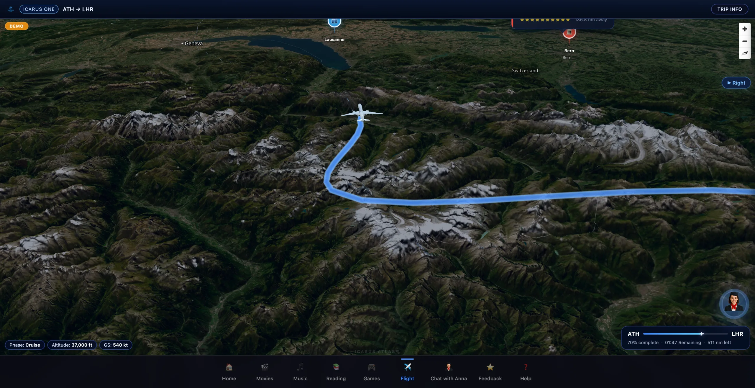
Icarus Atlas™: 3D Satellite Terrain on a Portable IFE
Icarus Atlas™ is a real-time 3D flight map built into every Icarus One™ IFE System. It renders satellite terrain imagery — actual topography from space — under the aircraft’s live position. Mountains have depth. Lakes reflect. Cities have texture. The Alps look like the Alps.
It runs entirely offline. No internet connection required. No aircraft modification. No STC. The Icarus One™ system deploys in under one hour — plug it in, turn it on, passengers connect. Atlas is part of the experience from the first flight.
Five Camera Perspectives
- Chase view — following behind the aircraft, the classic flight simulator angle
- Right window — looking out the starboard side at passing terrain
- Left window — the port-side equivalent
- Cockpit view — forward-facing, as if sitting in the flight deck
- Free look — passengers explore the terrain on their own
This is not a rendering trick or a static animation. It is a live 3D globe with satellite imagery, driven by actual flight data — heading, altitude, speed, position — updated in real time. Points of interest appear as the aircraft passes landmarks, cities, and geographic features.
Why This Matters for Operators
Charter and VIP operators compete on experience. The aircraft interior, the catering, the crew — every detail signals quality. But the in-flight entertainment often gets overlooked because the alternatives are either too expensive (installed IFE at $100,000–$500,000+) or too basic (a tablet with movies on it).
Icarus Atlas™ changes the calculus. A passenger boarding a Global 6000 or a Boeing 737 sees a 3D satellite map that looks like it belongs on a flagship airline — except this one runs on a portable system that costs a fraction of installed IFE and requires zero aircraft modification.
Installed IFE Flight Map
- Flat 2D display
- Static dot + line
- $100,000–$500,000+
- Months of downtime for STC
- Aircraft modification required
Icarus Atlas™
- 3D satellite terrain globe
- Five camera perspectives + POIs
- Starts at $24,900
- Deploys in under one hour
- Zero aircraft modification
The Icarus One™ IFE System also includes Anna VFA™, an AI virtual flight attendant that speaks over 30 languages — entirely offline. A passenger flying Abu Dhabi to Geneva can ask Anna about the flight in Arabic, French, German, or English without the system ever touching the internet.
Atlas and Anna together represent a category of portable IFE that did not exist before: one where the passenger experience rivals or exceeds what major airlines offer, without requiring the infrastructure those airlines spent millions to install.
The Technical Reality
Icarus Atlas™ runs on the Icarus One™ hardware — a portable, self-contained system covered by U.S. Patent No. 10,193,945 for portable in-flight entertainment with integrated flight tracking. No server farm. No satellite uplink. No aircraft integration. The system serves up to 500 passengers simultaneously over its own local Wi-Fi network.
The terrain data, satellite imagery, and 3D aircraft models are all stored locally. Flight position comes from integrated GPS. Everything a passenger sees — the map, the terrain, the aircraft, the points of interest — renders on-device, in real time, without external connectivity.
One Person Built This
Icarus IFE Systems LLC is not a division of a defense contractor or a subsidiary of a multinational. It is a one-person company that decided the state of in-flight maps was unacceptable and built something better.
The same system that renders 3D satellite terrain over the Swiss Alps also runs a multilingual AI flight attendant, serves a full entertainment library, and deploys without touching the aircraft. At a price point that starts at $24,900.
In-flight maps have not changed in 20 years. They just changed.